THE CHALLENGE OF GUNONG KINABALU. MOUNTAINEERING IN NORTH BORNEO
By Captain M. Ough Dealy, B.Sc.(Eng), R.E.M.E.
Introduction
Faced with the problem of another move, and having to decide on what to keep and what to throw away, I came across an old exercise diary. Glancing through it, I found an entry for the 6th June, 1960, which started: "Day spent in preparing for expedition to Kinabalu .-Plan to leave at 0545 hrs. tomorrow. . . ." This started me off on a red herring which did not help my packing but produced a flood of pleasant memories, which were helped by my finding some old colour slides lying on a pile of paper I had intended to throwaway; they reminded me, too, that I had once made the resolution of writing some day about the experience, but that I had yet to do so. It would be a pity if no record were made of what is believed to be the first all-R.E.M.E. expedition to climb the highest mountain in South-East Asia.
Gunong Kinabalu
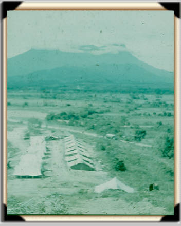
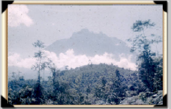
The mountain, 13,455ft. at its highest point, dominates the Kota Belud Training area in North Borneo. It is a magnificent sight, a truncated cone rising from the jungles of the interior to a rocky, windswept and utterly bare plateau some 12000 feet high. The plateau has been formed from the denuded neck of a prehistoric volcano. Its edges rise to several peaks, rather like immense teeth of some gigantic saw, from which numerous cascades of water fall in every direction. The Dyaks of Borneo believed at one time that a lake existed at the top of this mountain and that it was to be their receptacle after death.
Its immense bulk is visible even from Jesselton, 50 miles to the south, and to some people it presents a most forbidding aspect-so forbidding indeed that the local tribes, particularly the Dusuns, have long regarded it as a sacred place-the dwelling of the spirits of their dead. Although the Dusuns have been in contact with Western influence for many years, they still regard Mount Kinabalu as sacred and they view intrusion on its venerated flanks with dislike. In fact it is necessary to obtain the permission of the local District Officer to climb the mountain, and to give the conditional guarantee to observe the local custom of sacrifice. By doing so it is hoped that the spirits which are said to inhabit the peak will be pacified and less likely to wreak their vengeance later.
There is no doubt that Kinabalu is a wonderful sight, never more so than when it reappears, as solid and defiant of the elements as ever, after one of the weather's ceaseless attacks upon its defenses. With towering, inky black clouds laced with fearsome flashes of lightning, storms burst upon the summit with unending ferocity, only to roll back and leave the mountain glorying in its lonely splendour. No wonder the locals have called it "Lonely Father"; and no wonder, too, that so many have been challenged to strive for its summit and discover its secrets.
Planning
Kinabalu did not go unchallenged for long after troops for Exercise "Jungle Ring" had arrived in the Kota Belud Training Area. Parties from the 1/6 Q.E.O. Gurkha Rifles and 2nd Field Regiment R.A. made successful attempts, and it was not long before a R.E.M.E. party set out to emulate them
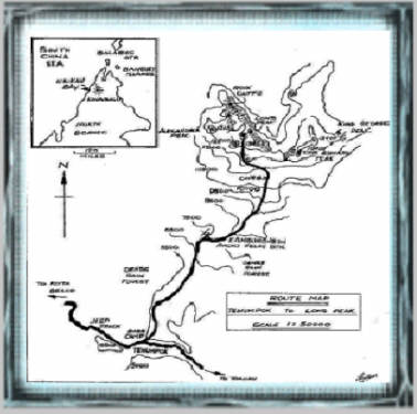
It appeared that there were three possible ways of tackling the task, reckoning on taking three days to achieve the summit and return to base-a far cry from the earliest attempts which took anything up to nine days. The first climbers were faced with a long trek through the jungle, following the course of a river, and were restricted to the use of water buffaloes for transport. Civilization has brought with it a road cutting through the foothills of the mountain, which enables parties to travel by Land Rover to the starting point at the village of Tenumpok
The track to the summit starts from the village at an altitude of about 5000 feet, cutting its way through the rain forests to a Telecommunications station perched on the mountain's flank at about 8000 feet.; from there it winds its way along a ridge, climbing precipitously to the "Pahka-Pahka" caves some 3000 feet. higher. 1000 feet above the caves, the track climbs above the tree line onto the solid rock of the ultimate heights.
The three ways of undertaking the climb are as follows.
The first is to climb from Tenumpok direct to the Pahka-Pahka caves, staying there for one night. The next day the climb to the summit is made, followed by return to the village for the second night. Return to base is made on the third day.
The second choice is to climb for the radio station on the first leg staying there for the first night. A very early start is made next day to reach the Pahka-Pahka caves for dawn and breakfast. This is followed by the attempt on the summit and return to the radio station, and the comfort of a bed and fire place for the second night. The return to Kota Belud via Tenumpok follows on the third day.
The third way is to climb from Tenumpok as lightly loaded as possible, getting to the summit and returning non-stop to the village. This last alternative is reserved for people of the climbing ability and stamina of Gurkhas and we did not consider it seriously. Several climbers from the Gurkha Battalions have done it this way, rivaling one another to achieve the quickest ascent. The record stood in the region of 13 hours, and was purely of academic interest where we were concerned!
Two members of the detachment were sent as a reconnaissance party with the climbers from 'N' Battery of 2nd Field Regiment. They achieved the climb, using the first method described, but came back in such a state of exhaustion that in the end it was decided to make the main R.E.M.E. attempt using the second method.

The Climb
By the 5th June, all was ready; the District Officer at Kota Belud,. Mr. G. Douglas, had very kindly obtained for us the necessary permission to climb, and had arranged for a guide to meet us at Tenumpok. The Public Works Department had given its sanction to use the road into the interior. Permission was necessary because it was open to traffic in periods of fine weather only, and for one-way traffic at that.
June 6th.-
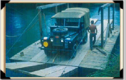
Our party of eight left Kota Belud on schedule at about 05.45 hrs. and settled down for a long grinding journey of four hours to the foothills. Our route left the main Jesselton-Kota Belud road at Tamparuli, where it became a single jeep track winding, and it seemed climbing interminably, to the interior.
The journey along this track alone provided thrills to satisfy the most in trepid traveler. For much of its length, it is wide enough only to cater for one Land Rover. It follows the top of a series of ridges, with sheer drops of over 1000 feet on one side and cliffs rising to awe-inspiring heights on the other. Foolhardy is the man who puts his foot down on this road!
At Tenumpok we spent about half-an-hour re-organising and just after 10 o'clock, leaving one man to look after the Land Rover and prepare for our return, the remainder of the party headed along the trail to the radio station.
Leading the party strode our guide Gunting, a Dusun headman who's knotted, bulging leg muscles testified to his prowess as a hills man. Recognized as one of the leading-guides in the area, he couldn't remember how many times he had climbed the formidable bulk which now lay so close ahead.
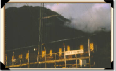
Loaded as we were with food and clothing, we found the climb to the radio station the most arduous part of the task ahead. Each man carried about 30 pounds of kit, and towards the end of the first leg, this load seemed to treble its weight. Our arrival at the radio station provided us not only with a sense of relief but also of achievement. Our light heartedness was dampened somewhat however, when to our chagrin we were told that every item on the radio station had been man-packed to the site. This included fly-wheels weighing over 170 pounds. for the generator These pieces were carried by two sturdy Dusuns in less time than it took us to struggle to the station!
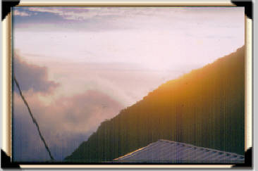
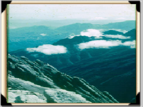
That afternoon and night we sorted out the food and essential items of kit required for the final stages next day, recuperated and enjoyed the fabulous view. It was panoramic, giving a wonderful vista of the country over which we had come. One could see the road along which we had travelled snaking its way through the lush valleys and bare ridge tops. In the distance the coast and South China sea could be seen. These views all promised even better things from the peak itself and made us eager to get started.
June 7th.-
Rising at 2 a.m. we set off in the cold and dark using torches find our way. Gunting, leading again, seemed to have a cat's instinct for finding his way through the dark. Silent as a ghost, he strode ahead with incredible confidence, leaving us to follow in his wake as best we could...... falling, stumbling and cursing over the countless tree roots, mud holes and creepers.
We proceeded in this manner for about 2 hours, when, just as dawn was breaking, Gunting disappeared into the bush on one side. We wondered whether he was off to make use of the extra $5.00 we had given him for the cock bird, tobacco and rice necessary for the pacification of the Kinaringan - the spirits of the dead. It seemed very mysterious. But then someone remarked that he did not think Gunting had brought a bird or anything else for that matter necessary for the rites required to propitiate the mountain spirits.
Anyway this was the only time that Gunting disappeared, and as he certainly had at no other time performed the rites about which we had heard so much we assumed that this was the occasion. One or two skeptics in the party scoffed at the idea reckoning that he'd gone off only to answer the calls of nature. This seemed hardly the traditional way of paying his respects, so I am sure that his disappearance was really all for the good of the mountain and its spirits.
Shortly after this episode we reached the Pahka-Pahka caves. Despite the fact that we had been carrying the lightest of loads-food for two meals only, the arrival at the caves proved a very welcome break. We soon had breakfast cooking and some much needed hot tea passed around. The cold at this altitude of 11000 feet was intense and, as the sun had only just appeared, a warming drink was in great demand.
The main cave is situated beneath a gigantic boulder, at least 100 feet high and one of many which are found here, lying about as if left there by some monstrous upheaval. There were many signs of previous climbers at the site; left there I suppose by parties who had spent what must have been a mostt uncomfortable night at this forbidding place.
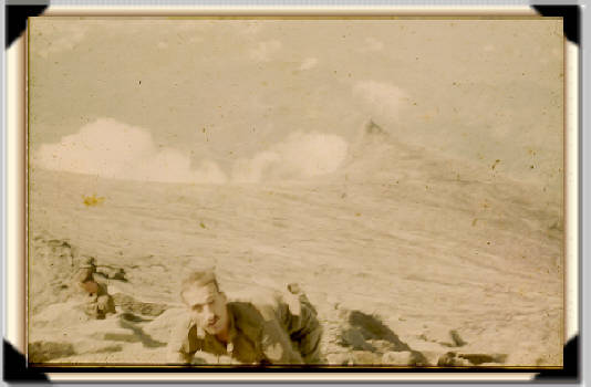
Taking with us only our cameras and one haversack containing first aid gear we departed for the summit soon afterwards. The track quickly took us above the last of the vegetation and onto bare granite. Our way was now marked only by a series of rock cairns; no track could ever have been worn into such hard unyielding stone. Plodding seemingly forever upwards, it appeared an eternity before we reached the edge of the plateau.
We were, inevitably, finding breathing harder because of the altitude. So we stopped for another rest. Actually we felt we were making pretty good progress and were making self congratulatory comments to boost ur egos and morale. But these soon ended in stunned silence as we heard the sound of running feet behind us and then a platoon of the 1/6 Ghurka Rifles ran, yes, ran past us up the steep path. Every one of them seemed to be grinning cheerfully and hardly puffing as they galloped by. I later learned that they had set of that morning from the road and were "knocking off" the mountain in one day. They passed us again later on their way down just as we reached the plateau. We all felt somewhat smaller after that but more determined than ever not to be defeated by Kinabalu.
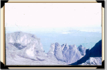
Then we finally reached the edge of the plateau where the ground sloped steeply to the south. Rising in waves, the granite gave the impression of a sea turned to stone in the middle of a storm, the edges of the plateau rising to form the peaks which gave the top such a ragged appearance when seen from Kota Belud.
Directly in front of us lay Low's Peak, the highest point, and at half past eight that morning we reached its top. The memory of that moment will never be surpassed; perched as we were on what seemed to be the roof of the world, with the sun rising in a cloudless sky, the whole of North Borneo lay at our feet.
To the west lay the plains of the Kota Belud and Usikan Bay. In the far north the Straits of Balabec could be seen and in the extreme distance the Banguey Islands were just visible. To the south Borneo disappeared inan unbroken sea of green, mysterious, wild, magnificent.
Rather closer and of much more frightening aspect, the sheer cliffs of the northern face of the mountain. These dropped almost vertically from our feet on Low's Peak to the forests below; a drop of at least 2,000 feet, the black bastions of rocks forming Kinabalu's most defiant and as yet unconquered side.
Reveling in this tremendous view, the temptation to stay longer was great. But by nine-thirty the clouds billowing up from the slopes below warned us that we had outstayed our welcome. Leaving our own names behind us in the bottle where all previous climbers had left theirs, we departed reluctantly; taking care first to put the bottle back in its protecting pile of rock.
The return went without incident. Stopping at the caves for the last time to have lunch, we forced weary legs, bursting lungs and blistered feet down to the radio station for a meal and well earned rest.
June 8th.
Carrying all our kit this time, we returned to Tenumpok to find the Land Rover and yet another welcome meal-a morale booster if ever there was one! Not long after this we started on the dirty, hot and hair-raising ride back to camp, leaving the mountain with real regret.
Conclusion
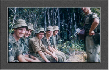
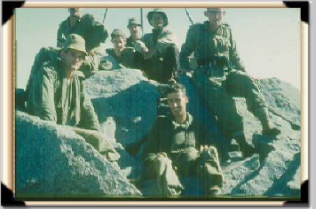
We carried out the climb as a R.E.M.E. team and everyone played their part well. 2/Lt David Nielson with Craftsman Foot did very well by doing the initial reconnaissance and enabling the main team to take an easier option for the climb. Staff Sergeant Webber was a tower of strength on the climb. He kept the rear position in the order of march without complaint, yet this was the hardest role because of the constantly changing pace. Cfn. Jagger was another strong climber whose imperturbability did much to keep up the team's morale; and Cfn. Simpson was invaluable as a resourceful cook.
We returned with the satisfying feeling that we had met the challenge of Kinabalu. But one could never say that this defiant, magnificently lonely mountain could ever be conquered. It had presented us with no great test of mountaineering, yet as a test of endurance under tropical conditions, it was a great adventure gilded by the comradeship of fellow soldiers.
After note: The following made up the full R.E.M.E. team
Reconnaissance Party: 2/Lieut. Nielson, Cfn. Foot.
Main Party: Capt. Dealy, S/Sgt. Webber, L/Cpl. Silman,
L/Cpl. Whittaker, Cfn. Sutton, Cfn. Simpson, Cfn. Forward, Cfn. Jagger.
WORK IN PROGRESS
Malaysian andCopyright of all parts of this site is owned by M.& M.M. Ough Dealy
This page last modified on Monday, 16 August 2021